Log in
All resources
Create a design
298 Free Artworks of 1880s Maps
maps from the earth and its inhabitants, vol. iv
historical sketch book and guide to new orleans and environs (1885)
atlas des anciens plans de paris by imprimerie nationale, 1880 from bhvp
koizumi yakumo
1880s maps of the british isles
maps from the earth and its inhabitants, vol. v
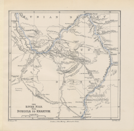
too late for gordon and khartoum (1887) by macdonald
maps of the mahdist war
maps from the earth and its inhabitants, vol. iii
shores and alps of alaska (1887)
inventio fortunata. arctic exploration. (1881)
johannes ruysch
géographie du département d'ille-et-vilaine (1881)
19th-century maps of ille-et-vilaine
too late for gordon and khartoum (1887) by macdonald
1880s maps of sudan
too late for gordon and khartoum (1887) by macdonald
maps of the mahdist war
shores and alps of alaska (1887)
1880s maps of alaska
maps from the earth and its inhabitants, vol. iv
severn estuary
atlas des anciens plans de paris by imprimerie nationale, 1880 from bhvp
map of paris by françois quesnel
shores and alps of alaska (1887)
1880s maps of alaska
shores and alps of alaska (1887)
1880s maps of alaska
shores and alps of alaska (1887)
1880s maps of alaska
atlas des anciens plans de paris by imprimerie nationale, 1880 from bhvp
plan de roussel - partial files
maps from the earth and its inhabitants, vol. iv
falmouth bay
maps from the earth and its inhabitants, vol. iii
old maps of hungary
maps from the earth and its inhabitants, vol. iv
montrose, angus
maps from the earth and its inhabitants, vol. iv
dublin bay
maps from the earth and its inhabitants, vol. iv
milford haven
maps from the earth and its inhabitants, vol. iii
maps of blankenberge
ghosts & ghoulish scenes
maps from the earth and its inhabitants, vol. iv
1880s maps of the british isles
maps from the earth and its inhabitants, vol. iv
1880s maps of ireland
maps from the earth and its inhabitants, vol. iv
1880s maps of the british isles
maps from the earth and its inhabitants, vol. iv
1880s maps of the british isles
maps from the earth and its inhabitants, vol. iv
1880s maps of the british isles
maps from the earth and its inhabitants, vol. iv
1880s maps of the british isles
maps from the earth and its inhabitants, vol. iv
1880s maps of scotland
maps from the earth and its inhabitants, vol. iv
1880s maps of the british isles
maps from the earth and its inhabitants, vol. iv
1880s maps of the british isles
maps from the earth and its inhabitants, vol. iv
old maps of cambridge
maps from the earth and its inhabitants, vol. iv
old maps of lincoln
maps from the earth and its inhabitants, vol. xviii
1890s maps of colombia
maps from the earth and its inhabitants, vol. iv
1882 maps
maps from the earth and its inhabitants, vol. iv
1881 maps
maps from the earth and its inhabitants, vol. iv
old maps of sheffield
too late for gordon and khartoum (1887) by macdonald
maps of the mahdist war
maps from the earth and its inhabitants, vol. x
old maps of ethiopia
maps from the earth and its inhabitants, vol. iv
old maps of the isle of arran
maps from the earth and its inhabitants, vol. iv
old maps of sheffield
maps from the earth and its inhabitants, vol. v
old maps of the black sea
maps from the earth and its inhabitants, vol. iv
19th-century maps of the isle of wight
maps from the earth and its inhabitants, vol. iii
old maps of trier
maps from the earth and its inhabitants, vol. v
19th-century maps of crimea
maps from the earth and its inhabitants, vol. iv
old maps of lincoln
maps from the earth and its inhabitants, vol. iv
old maps of portsmouth
maps from the earth and its inhabitants, vol. v
19th-century maps of scandinavia
maps from the earth and its inhabitants, vol. iv
old maps of norwich
maps from the earth and its inhabitants, vol. iii
19th-century maps of europe
maps from the earth and its inhabitants, vol. iv
19th-century maps of the isle of man
maps from the earth and its inhabitants, vol. v
old maps of the dnieper river
atlas des anciens plans de paris by imprimerie nationale, 1880 from bhvp
baroque
old maps of the franco-prussian war
alfred quesnay de beaurepaire
cassell's old and new edinburgh (1880s)
holyrood palace
nouveau cours d'instruction primaire de géographie (1886)
1880s maps of the americas
too late for gordon and khartoum (1887) by macdonald
maps of the mahdist war
too late for gordon and khartoum (1887) by macdonald
maps of the mahdist war
atlas des anciens plans de paris by imprimerie nationale, 1880 from bhvp
dheulland map of paris
atlas des anciens plans de paris by imprimerie nationale, 1880 from bhvp
proletarian literature
atlas des anciens plans de paris by imprimerie nationale, 1880 from bhvp
plan de turgot
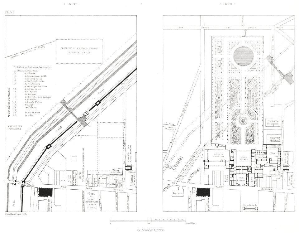
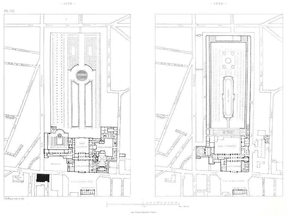
engravings of palais royal by theodor hoffbauer
lithographs of paris
1100 block of royal street, french quarter
1885 in new orleans
maps from the earth and its inhabitants, vol. iv
atlas des anciens plans de paris by imprimerie nationale, 1880 from bhvp
baroque
atlas des anciens plans de paris by imprimerie nationale, 1880 from bhvp
turgot map of paris, bibliothèque historique de la ville de paris
swamps in louisiana
1885 in louisiana
europe in storm and calm (1885)
1885 maps of europe
orleans street, french quarter
arecaceae in new orleans
historical sketch book and guide to new orleans and environs (1885)
madame john's legacy
engravings in musée carnavalet
plan de turgot
houses in the french quarter
koizumi yakumo
historical sketch book and guide to new orleans and environs (1885)
houses in new orleans
birds-eye view of seattle, 1884
ships in puget sound
vegas färd kring asien och europa
fra mauro map derivative works
engravings of palais royal by theodor hoffbauer
lithographs of paris
maps from the earth and its inhabitants, vol. iv
middlesbrough
maps from the earth and its inhabitants, vol. v
velikiy novgorod
maps from the earth and its inhabitants, vol. iv
maps from the earth and its inhabitants, vol. iv
maps from the earth and its inhabitants, vol. iv
maps from the earth and its inhabitants, vol. iv
maps from the earth and its inhabitants, vol. iv
maps from the earth and its inhabitants, vol. iv
maps from the earth and its inhabitants, vol. iv
historical sketch book and guide to new orleans and environs (1885)
koizumi yakumo
historical sketch book and guide to new orleans and environs (1885)
koizumi yakumo
historical sketch book and guide to new orleans and environs (1885)
koizumi yakumo
dr. wilh. junker's reisen in afrika 1875-1886
1880s maps of egypt
toyohara chikanobu
ukiyo-e
maps from the earth and its inhabitants, vol. iv
maps from the earth and its inhabitants, vol. v
maps from the earth and its inhabitants, vol. iii
monnickendam
la hongrie de l'adriatique au danube. impressions de voyage (1883)
1880s maps of austria-hungary
la hongrie de l'adriatique au danube. impressions de voyage (1883)
1880s maps of austria-hungary
maps in the rijksmuseum amsterdam
emrik & binger
carte de l'afrique françoise par guillaume delisle (1726)
philippe buache
nineveh and babylon - a narrative of a second expedition to assyria during the years 1849, 1850, and 1851 (1882)
maps of babylon
nineveh and babylon - a narrative of a second expedition to assyria during the years 1849, 1850, and 1851 (1882)
maps of nimrud
the geographical distribution of the family charadriidae (1888)
distribution maps needing taxon category
19th-century portrait paintings in the national portrait gallery, london
benjamin robert haydon
the soldier in our civil war - a pictorial history of the conflict (1893)
1860s maps of the united states
201 - 298 of 298
/ 3